Hiking in Greece
In the footsteps of the Centaurs—
The Stone Walkways of Mount Pilion
|
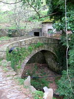
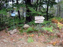
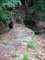
By Janet McGiffin Centaurs—the half man, half horse legends of Greek mythology—lived in the dense forests of Mt. Pilion, the mountain range that covers most of the wooded peninsula that juts into the Aegean Sea midway between Athens and Thessaloniki. Walking the ancient stone footpaths under the misty and silent canopies of tall trees, I wouldn’t have been surprised to turn a corner and see Chiron, the wisest of the Centaurs, still instructing Achilles in the art of music. The Pilion peninsula is breathtakingly beautiful, from the beachside villages to the big wood and stone houses high on the forested slopes. The villages are connected by stone footpaths called “kalderimi” which linked the peninsula before there were roads. Mule trains traversed them bringing wares up from ships. Now these lovely stone footpaths are well-maintained and even being expanded by local hiking clubs. Hiking is best in the cooler spring and fall, but the trekking season can expand into the summer months thanks to the altitude of Mt. Pilion (1,651 m) and the breezes off the sea and mountains. In spring, however, the blooming apple orchards make hiking a magical experience, and in fall, the chestnut orchards and in their fall colors make this season truly gorgeous. Hiking maps of Mt. Pilion are put out by Road Editions and are available in most large bookstores in Athens or in tourist shops. The mapped footpaths don’t correspond well with actuality, however, but a combination of following the trail blazes and the directional signs, plus using the map to get an overall idea of the area, will make you confident of your footpath. Traversing the Mt. Pilion peninsula from one side to the other means hiking a circular route, returning by the same footpath, or coordinating your walk with the local bus schedules. Bus schedules in Greek can be obtained from the ticket window at the KTEL bus terminal in Volos and with help from the clerk, arrival times at villages can be determined. The problem is that buses are few and don’t serve all the villages. And there are two bus routes, one for the Aegean side and one for the Pagasitikos Gulf. It can be difficult to make the connection. An alternative is to hire a taxi to pick you up at the end of your hike, at a designated time and place. This expensive luxury is well worth it after four to six hours on stone footpaths, especially since evenings in spring and fall can be damp and nippy. To make sure you meet your taxi at the right time, someone in your group should carry a mobile phone that operates in Greece. After all, you might be delayed by a leisurely noon-time nap somewhere in a high meadow. An excellent spring hike for lovers of apple orchards in bloom starts at Agios Georgios Nilias, a small village on the Pagasitikos Gulf that has a number of pleasant lodgings, tavernas, and an excellent restaurant. The well-marked route varies between apple orchard roads and footpaths and leads over the Mt. Pilion peninsula and down into Tsagarada on the Aegean Sea. As there is no bus service to Agios Georgios Nilias, return must be by arranged taxi. Or, hikers with sturdy legs can return to the Pagasitikos Gulf side via Xourichti and the beautiful stone footpath to Milies—then take a taxi from there to Agios Georgios Nilias. It’s a 25 minute taxi ride—shorter and less expensive than from Tsagarada. Another alternative is to find lodgings in the village next to Agios Georgios Nilias, Pinakates, which does have bus service. In the morning, ask someone at your lodgings to take you up to Agios Georgios Nilias, walk the route to Milies, then catch the bus to Pinakates. Before making your decision, make sure of the bus schedules. The hike from Agios Georgios Nilias to Tsangarada takes about four hours. The hike between Agios Georgios Nilias, Tsagarada, Xourichti, and Milies is about seven hours, including leisurely stops for picnics and photo-ops. However, the hike from Agios Georgios Nilias to Milies can be shortened greatly by cutting out Tsagarada and Xourichti and following the directional signs directly to Milies, as will be explained below. The hike: Agios Georgios Nilias to above Tsagarada to above Xourichti, to Milies: 7 hoursStart in Agios Georgios Nilias at the Plateia located on the uphill side of the main road. The stone footpath starts between the tavernas and leads steeply upward. In a few minutes, you will step up onto a dirt road between houses. To your left is a lovely church next to a stone bridge. Your route, however, is to the right. Jog right, then left again up the stone pathway. It’s marked on the stone wall to the left. There is also a sign to the lodgings, Nefeli. Follow the winding stone path upward past the Nefeli and out of the village. You pass a sign Ουρανος (Heaven). Follow the red blazes. Soon you will reach a well-posted bifurcation of the route. The multiple wooden signs are all in Greek, but even non-Greek readers can make out the Greek word Τσαγαραδα. (Tsagarada). In any case, your route is to the right, stepping over the narrow cement irrigation channel. Your trail wanders by apple orchards and through low vegetation and veers onto a dirt road used by apple orchardists. Follow this road to the right through the apple orchards until it divides into three roads. One road leads to the right to a farm house. One leads sharply left, over your left shoulder and upwards. The third leads to the left and inclines downward. Take this last road to the left, which has a red blaze. Now keep an eye out for the red trail blazes and the trail directional signs. Not far ahead of you, at the point where the road turns to the right, is your footpath. It leads straight ahead and upwards into the dense foliage of the woods. From now on, your footpath is well marked by red blazes on rocks, trees, and even on the orchard roads themselves whenever the path merges with the road. When in doubt, stand still and look for the red blaze or a directional sign. The route is delightfully varied. Apple orchards blend into dense oak and chestnut forests which in turn open to rocky vistas of the sea and the hills ahead. In autumn, chestnut pickers are gathering chestnuts under the towering trees and loading donkeys with bags of the pungent nuts. The route passes three small water reservoirs, always on your right. Goats and sheep abound. It is not a strenuous hike. Elevations are rarely over 1,000 meters, and the path drops only a few hundred feet before rising again. The summit is obvious—you’re in an open space in the forest with vistas all around, and then the trail drops downward. But watch the blazes at the summit! Your footpath leads to the left—not to the right on the forestry utility road. After you have crossed the summit and are strolling easily through kilometers of tall trees with barely an opening to the sky, you will reach a set of directional signs. Tsagarada is straight ahead another 40 minutes. However, for those who want to return to Milies at this point, take the path marked ‘Milies’ (Μιλιες), to the right. Those wanting a longer hike to Milies, continue straight ahead toward Tsagarada. My hike took me straight ahead. In another 40 minutes is another choice—whether to turn left down into Tsagarada or whether to turn right and follow the chestnut orchard road to Xourichti (Ξουριχτι) and onward to Milies. This is the route I followed, and enjoyed every minute. The road winds downward through enormous chestnut trees and apple orchards. Soon you are at the trail head to Milies, extremely well-marked with map. It is an exceptionally beautiful footpath. Kalderimi nearly all the way, the lower elevation is easy on legs that are beginning to tire. And the vistas of sea and hills are magnificent. After a few relaxing hours of easy hiking, before you know it, you are dropping into Milies. Reaching the boundary of the village of Milies, continue straight ahead on the village pathways as long as you can before turning downward into the village center. Keep an eye out for the church steeple. This is the plateia, with the bus stop, the famous church of Agios Taxiarchis, and the best place to meet your taxi. You may even have time for an ouzo and a nip into the shops for delicious locally preserved walnuts, chestnuts, and fruits. Janet McGiffin lives in Athens partly because it is so easy to travel to anywhere from Greece. She is a writer of mystery novels and travel articles. She also writes grant proposals for non-profit organizations (NGO) based around the Mediterranean. Currently she is public-education publicist for a 24-partner European Union cultural project involving conservation of ancient monuments. You can e-mail her at janmcgiffin@yahoo.com Getting to PilioKTEL intercity bus: Athens -Volos -Athens 4 ˝ hours each way 37 Euros. You can also take the train to Volos. Taxi services in Volos: Lodgings: Booking.com's Pelion Page Recommended: Aiolis Hotel For more on Pilion see www.greecetravel.com/pelion |
|
|
Questions? E-mail Matt
|
|
|
|
|
Help Support Matt's Greece Travel Guides |
|